Site Specific Seismic Design Parameter Studies
Seismic design parameter studies are essential for hydro power, PSP, Thermal plants, Nuclear plants and large civil infrastructure projects. SRT and MASW provide critical information for design of response spectrum and liquefaction potential assessment. DM consulting has rich experience in providing all type of investigation, engineering parameters and data processing required for these studies and worked on several projects. Following are some of the studies.
Generation of Earthquake catalogue
Earthquake data within a radius of 300 Km around the project site is the primary required for seismic design parameter study. Such works have been done for number of projects.
Identification of Seismotectonic features
The major regional tectonic features along with the past earthquakes are required for estimation of distances of seismogenic sources from the site. Such works have been done for number of projects. The major tectonic features in the main Himalayan zone are the MCT, the MBT, HFT and many subsidiary thrusts sympathetic to MCT and MBT.
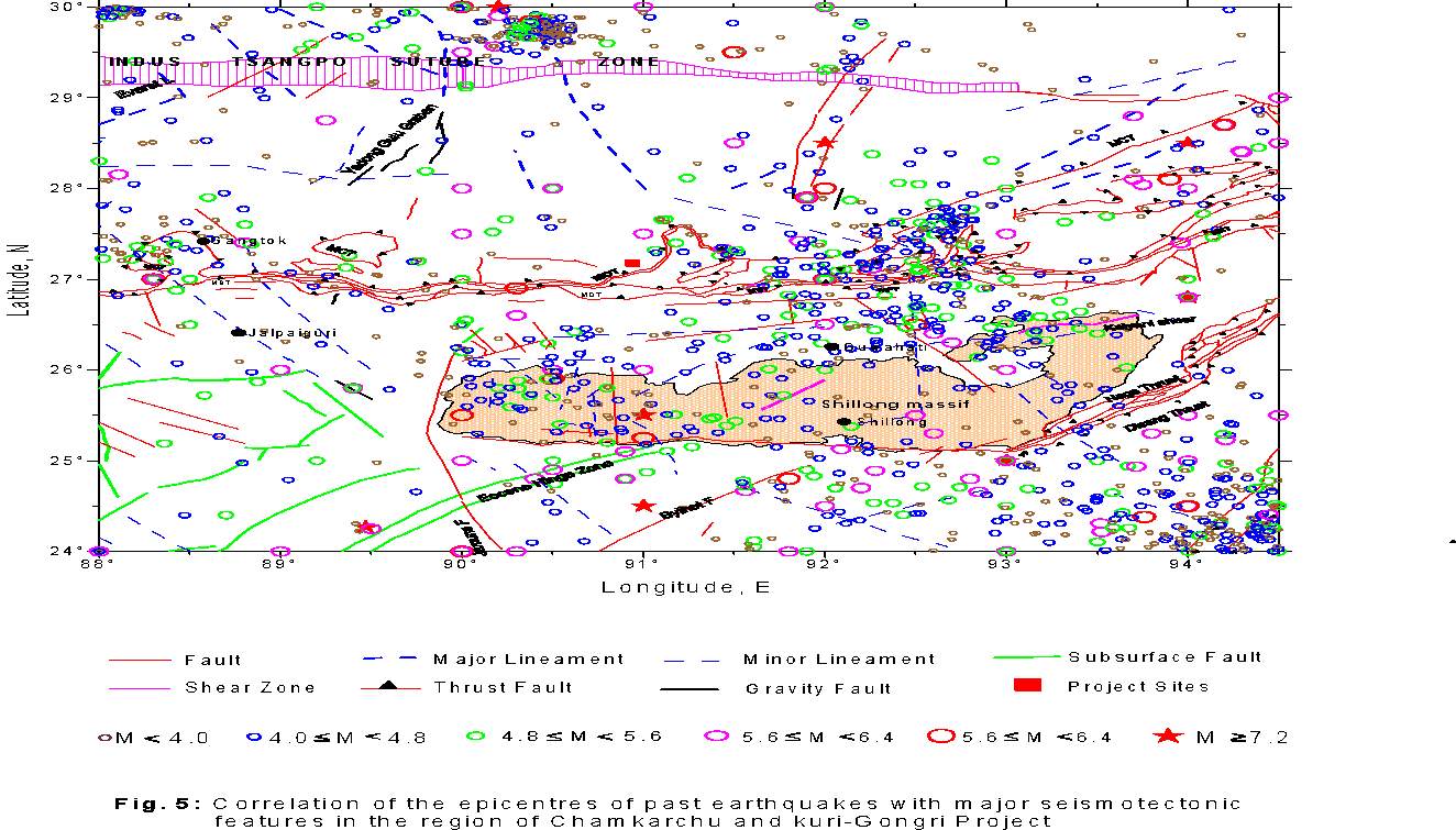
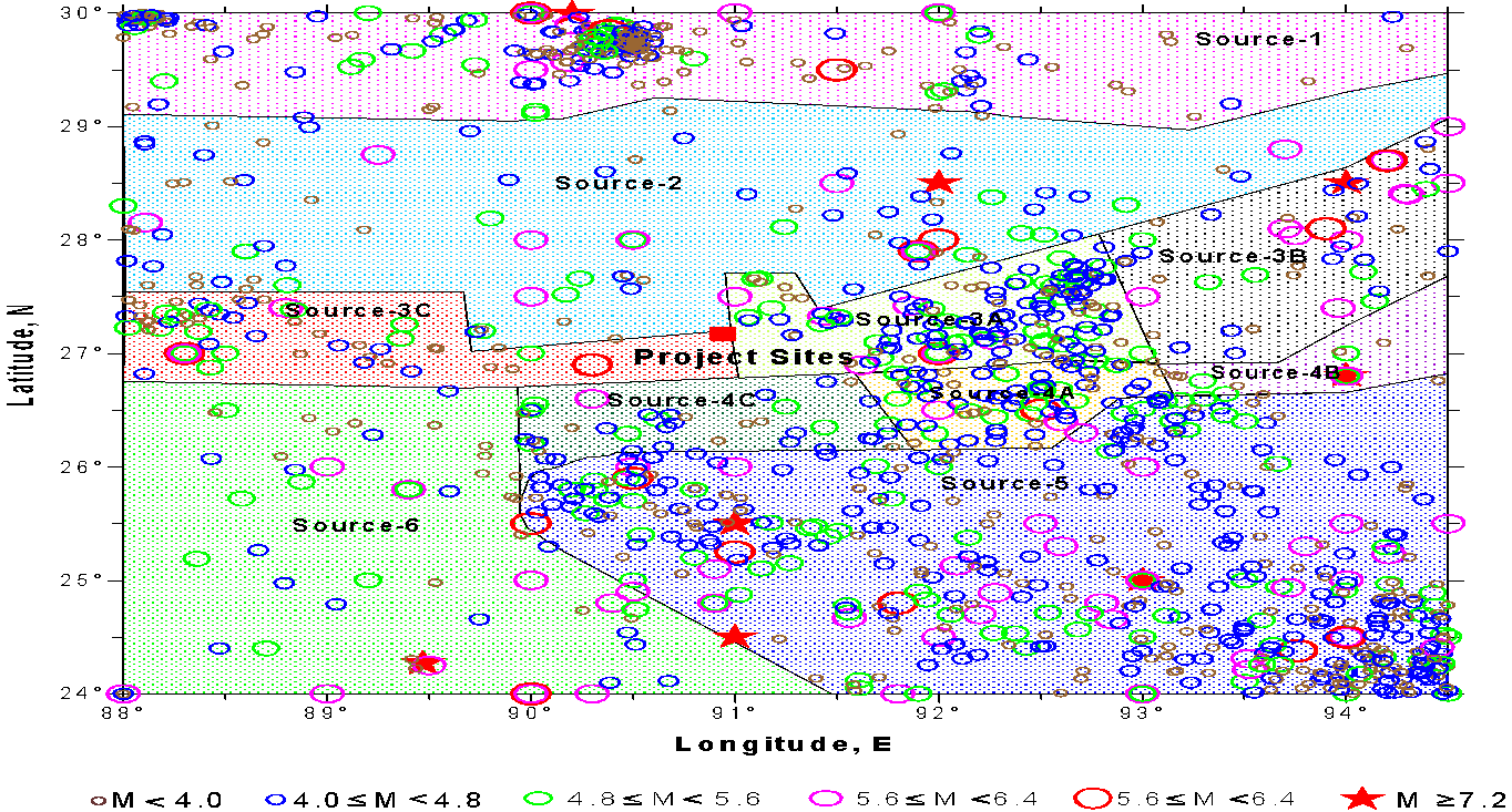
Identification of Seismic sources
A seismic source is defined as an individual fault, or an area of diffused seismicity with distinctly different seismogenic potential in terms of the maximum magnitude as well as the occurrence rate of earthquakes in different magnitude ranges. Considering the spatial distribution and correlation of seismic activity with the tectonic features in a region broad seismic sources can be identified for estimation of ground motion.
GROUND MOTION BY DETERMINISTIC APPROACH (DSHA)
The design ground motion by deterministic approach is estimated for a specific earthquake magnitude occurring at a fixed distance from the project site of interest using a attenuation law. Two different levels of earthquakes are considered for this purpose, one of which represents a rare but possible event, and the other a more likely event during the life of a project. These are termed as Maximum Credible Earthquake (MCE) and Design Basis Earthquake (DBE) respectively. The MCE is defined as the largest possible earthquake along a recognized fault or within a geographically defined tectonic province, under the presently known or presumed tectonic framework. The deterministic estimate of the DBE level of motion is taken to be half the MCE level of motion.
GROUND MOTION BY PROBABILISTIC APPROACH (PSHA)
The probabilistic seismic hazard analysis (PSHA) approach is used to consider the random and uncertain nature of seismicity as well as the ground motion attenuation. This approach considers the effect of total expected seismicity with suitable spatial distribution to evaluate the 5 % or with a more damping target response spectra for a project site. The spectra obtained by PSHA approach have the property that for a specified confidence level they will not be exceeded due to any of the earthquakes expected to occur anywhere in the region during a specified exposure time. PSHA incorporates the frequency of occurrence of earthquakes of different magnitudes on the various seismic sources and the uncertainty of the earthquake locations on the sources, and the ground motion attenuation including its uncertainty. Thus in the probabilistic approach, site ground motions are estimated for selected values of the probability of ground motion exceedance in a design time period or for selected values of return period of ground motion exceedance.
Applications
- Seismic hazard assessment for urban planning and infrastructure development
- Site classification (e.g., NEHRP, Eurocode 8) for compliance with seismic design codes
- Estimation of shear wave velocity (Vs30) for ground motion prediction and zoning
- Determination of peak ground acceleration (PGA) and response spectra for structural design
- Dynamic site response analysis to evaluate soil amplification and resonance behaviour
- Liquefaction potential assessment in soft or saturated soils
- Earthquake-resistant design of buildings, bridges, dams, pipelines, and other critical infrastructure
- Retrofitting and seismic strengthening of existing structures
- Microzonation studies for detailed seismic risk mapping at the local or regional scale
- Foundation design optimization based on local seismic and geotechnical conditions
- Tunneling and underground construction safety analysis in seismically active areas
- Post-earthquake damage assessment and reconstruction planning
Our Clients