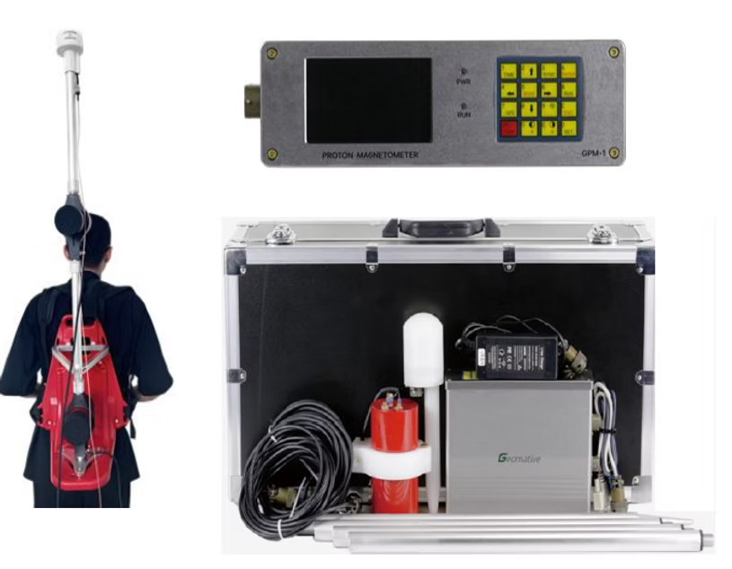
Proton Magnetometer
A Proton Magnetometer is a type of magnetometer used to measure the absolute strength of the Earth’s magnetic field. Due to its sensitivity, portability, and ease of use, it has a wide range of applications in geophysics, environmental science, archaeology, and defense. The GPM-10 Proton Magnetometer is a lightweight and portable device designed for ease of use in the field. It features a high-precision, temperature-controlled crystal oscillator (OCXO) for enhanced stability and accuracy. Equipped with standard GPS, it supports multiple satellite navigation systems including GNSS, GPS, BeiDou, and GLONASS, ensuring precise positioning and time synchronization. With a time sync accuracy of up to 30 milliseconds, it offers reliable performance and greater convenience. The GPM-10 also supports various operating modes, including mobile, walk, and base station configurations.
| Specifications | |
|---|---|
| Sensitivity : | 0.05nT |
| Dynamic range : | 20,000–120,000nT |
| Absolute accuracy : | ± 0.1nT |
| Resolution : | 0.01nT |
| Sample : | 3~60s @Mobile Mode; 3~3600s @Base Mode. |
| Gradient Tolerance: | >5000nT/m |
| Remote Control : | Optional remote control via RS-232 interface |
| Input/Output : | RS-232 via 10-pin weatherproof connector with USB adaptor |
| Internal Memory : | 32MB (209715 readings in Manual Mode, 699050 readings in Base Mode) |
| Dimension & Weight : | Console: 220mm x 70mm x 175mm, 1.57kg Sensors: 140mm(L) x 70mm(D); 1kg |
| Operating Temperature : | -40°C to +55°C |
Applications
- Engineering investigation
- Geothermal exploration including alteration mapping that detects changes in magnetic properties caused by hydrothermal alteration, structure identification helps in identifying fractures and conduits for geothermal fluids.
- Volcano observation including volcanic monitoring & fault mapping.
- Environmental and Groundwater studies including pollution studies and landfill mapping.
- Mineral exploration including mineral prospecting detects magnetic anomalies caused by ore bodies such as iron, nickel, geological mapping assists in identifying lithological boundaries, oil & gas exploration.
- Base station magnetometer for aerial and marine magnetic survey.
- Detection of small ferromagnetic objects.
- Archaeology including archaeological surveys for site detection, non-invasive investigations allows mapping of archaeological features without excavation.
Our Clients